Soil Moisture Estimation Using Ground-Based GNSS Reflectometry: A MAGDA Implementation by GReD
Understanding soil moisture is essential for efficient agriculture, water resource management, and environmental monitoring. GNSS Reflectometry (GNSS-R) offers a novel approach to monitoring soil moisture, but its operational application presents significant challenges.
Soil moisture is a critical factor for sustainable agriculture and effective water management. Traditional methods often struggle to combine precision with scalability. GNSS Reflectometry (GNSS-R), an innovative remote sensing technique, analyzes GNSS signals reflected off the Earth’s surface to infer environmental properties such as soil moisture. This article explores the implementation of ground-based GNSS-R within the MAGDA project, emphasizing its promise, challenges, and future potential.
Understanding soil moisture is essential for efficient agriculture, water resource management, and environmental monitoring. Traditional methods often struggle to combine precision with scalability, but GNSS Reflectometry (GNSS-R) presents a promising solution. This innovative remote sensing technique analyzes GNSS signals reflected off the Earth’s surface to infer environmental properties such as soil moisture. Unlike satellite-based GNSS-R, which is a highly promising technique that captures signals reflected from the Earth to satellites for large-scale analysis, this article delves into ground-based GNSS-R. This approach relies on signals reflecting back to ground stations, offering potential for localized monitoring—though its practical application remains challenging.
Exploring GNSS Reflectometry
At its core, GNSS-R relies on the interaction between GNSS signals and the Earth’s surface. When these signals encounter the ground, part of the signal reflects back. The reflected signal combines with the direct signal to form interference patterns, which are then analyzed to infer soil moisture. The soil’s dielectric properties, significantly influenced by its moisture content, determine the strength and phase of these reflections.
In the MAGDA project, ground-based GNSS-R technology is employed, leveraging data collected by fixed stations that are primarily used for the estimation of precipitable water vapour.
The MAGDA Approach: How Soil Moisture is Derived
MAGDA’s implementation of GNSS-R involves a multi-step process to extract meaningful data and estimate soil moisture effectively. The first step is signal analysis, where GNSS signals are carefully filtered based on azimuth and elevation to prioritize reflections under optimal conditions. Distortions caused by antenna gain patterns are removed, leaving only the reflection-induced interference patterns for further analysis.
Once the signals are cleaned, wavelet decomposition is used to isolate ground tracks on a consistent flat terrain. This method helps identify specific reflection points and refine the phase data within the interference pattern. The phase shifts detected in these patterns are crucial, as they hold the key to calculating soil moisture.
Environmental corrections are another critical step in the soil moisture retrieval process. Vegetation can dampen or distort the GNSS signals, while snow can completely disrupt the retrieval process, so adjustments are made to isolate and, when possible, mitigate these effects. For instance, normalized amplitude variations are analyzed to account for vegetation cover, while snow periods are excluded from the data to maintain accuracy.
Finally, the refined phase data is converted into volumetric water content using established scientific models. These models relate the observed phase shifts directly to soil moisture levels, providing a quantitative measure of water content in the upper soil layers. A bias correction is computed on the basis of forecast models at low resolution scales.
Challenges in Real-World Applications
While GNSS-R shows great promise, its application in real-world settings comes with substantial challenges that cannot be overlooked. Environmental factors like dense vegetation, uneven terrain, and snow-covered areas often interfere with the clarity of the reflected signals. These conditions, even when corrected for by MAGDA’s advanced techniques, can introduce complexities that reduce the accuracy of soil moisture retrievals.
Another critical issue lies in the operational constraints tied to satellite geometry. The reliance on repeated satellite positions, is essential for temporal consistency. Introducing additional constellations can complicate the unwrapping of phase changes, limiting the robustness of the analysis.
Validation also remains a pivotal task. Results obtained through GNSS-R need rigorous comparison with in-situ measurements or other reliable models to ensure they are representative across diverse environmental and operational conditions.
Finally, one of the most significant limitations of GNSS-R is its inability to precisely define the depth at which soil moisture is being sensed. While the technique primarily interacts with the top few centimeters of the soil, variations in texture, structure, and composition can shift the penetration depth. This ambiguity makes it challenging to directly correlate GNSS-R data with deeper soil moisture levels or with models that focus on subsurface conditions.
Results from the MAGDA Project
GReD’s implementation of ground-based GNSS-R has yielded promising results under controlled conditions:
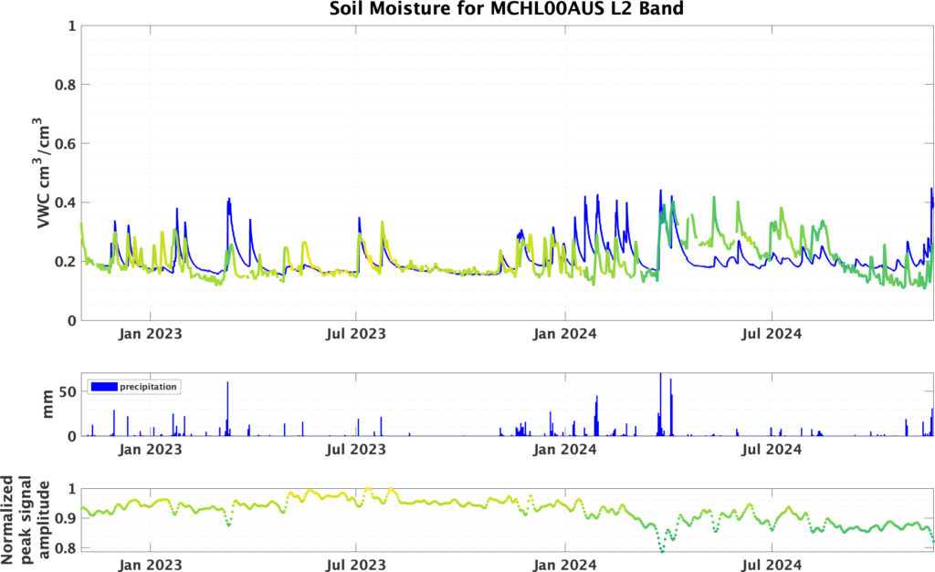
At the MCHL station in Australia, flat terrain and minimal vegetation provided near-ideal conditions for soil moisture monitoring. The correlation between GNSS-R-derived soil moisture and model datasets reached a moderate 0.46, demonstrating the approach’s reliability in optimal scenarios.

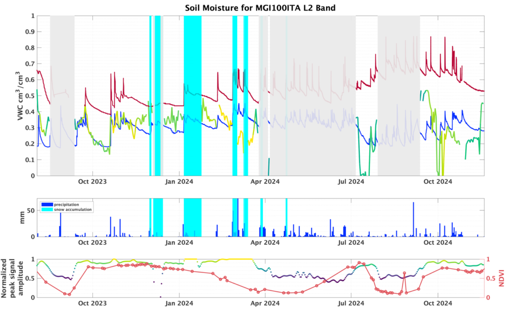
In contrast, the MGI1 station in Italy, deployed within MAGDA, faced challenges due to uneven terrain and periods of high vegetation. Reliable results were achieved during low vegetation seasons, but accuracy dropped significantly under dense vegetation and snow cover. These findings emphasize the importance of environmental suitability for successful GNSS-R applications.

The Road Ahead: Challenges and Opportunities
Ground-based GNSS-R has significant potential for precision agriculture, water management, and environmental monitoring. By enabling site-specific irrigation planning and real-time soil monitoring, it offers scalable benefits to farmers and resource managers. However, its current limitations restrict widespread adoption in operational scenarios.
The MAGDA project highlights the technology’s promise while acknowledging the hurdles—from vegetation interference to terrain variability—that must be overcome. Continued advancements in algorithm development, environmental corrections, and multi-sensor integration are essential for transforming GNSS-R from a promising research tool into a practical solution for global agriculture.
Conclusion
GNSS-R is an innovative method for soil moisture monitoring, offering a scalable and cost-effective alternative to traditional techniques under controlled conditions. MAGDA’s implementation demonstrates both the potential and the challenges of using ground-based GNSS-R. While operational deployment remains limited, the ongoing efforts of projects like MAGDA are paving the way for broader applications, making GNSS-R a key technology in sustainable agriculture and environmental stewardship.
Author
Andrea Gatti, Eugenio Realini
GReD srl
References
- Bevis, M., et al. (1992). GPS meteorology: Remote sensing of atmospheric water vapor using the Global Positioning System. Journal of Geophysical Research, 97(D14), 15787-15801. DOI: 10.1029/92JD01517.
- Chew, C.C., et al. (2016). An algorithm for soil moisture estimation using GPS-interferometric reflectometry for bare and vegetated soil. Hydrology and Earth System Sciences, 20(5), 1835-1852. DOI: 10.5194/hess-20-1835-2016.
- Small, E.E., et al. (2016). Validation of GPS-IR soil moisture retrievals: Comparison of different algorithms to remove vegetation effects. Remote Sensing of Environment, 173, 128-137. DOI: 10.1016/j.rse.2015.10.036.
- Ran, Q., et al. (2022). Editing arcs to improve the capacity of GNSS-IR for soil moisture retrieval in undulating terrains. GPS Solutions, 26(1), 19. DOI: 10.1007/s10291-021-01206-y.
- He, J., Zheng, N., Ding, R., et al. (2025). Soil moisture retrieval using GNSS signal-to-noise ratio data based on an improved optimal arc selection method. GPS Solutions, 29, 27. DOI: https://doi.org/10.1007/s10291-024-01786-5.
Keywords
GNSS Reflectometry, Soil Moisture Monitoring, Precision Agriculture, MAGDA Project, GNSS-R, Water Management, Vegetation Interference, Signal Processing
Images


“A visual comparison of two GNSS-R monitoring stations. The MCHL station in Australia, characterized by flat terrain and minimal vegetation, provides optimal conditions for soil moisture retrieval. In contrast, the MGI1 station in Italy faces challenges with uneven terrain and varying vegetation cover.”


