Innovative applications of GNSS for the agricultural sector
Do you know that GNSS technology, well-known for positioning applications, can be used to measure soil moisture and atmospheric water vapor? These and other innovative approaches to GNSS data processing will be addressed in the MAGDA project.
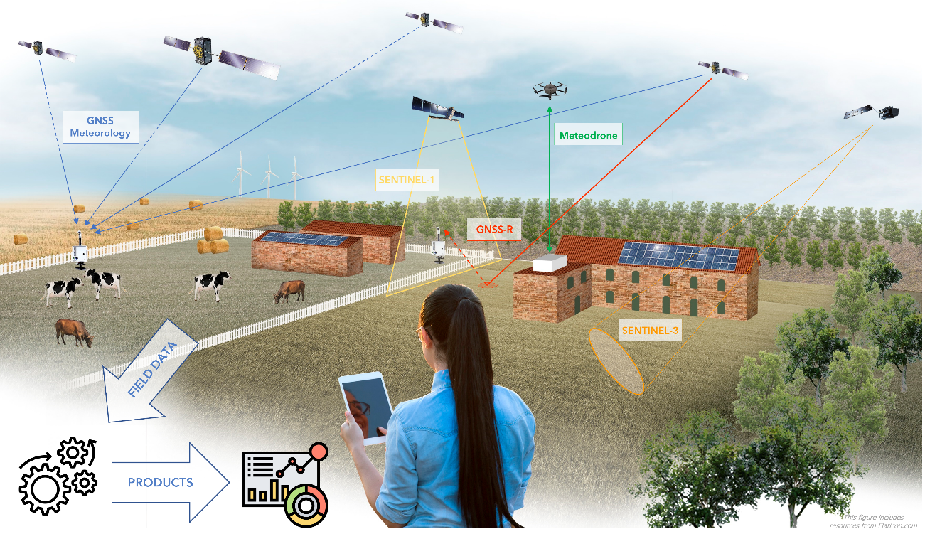
The MAGDA project is harnessing the power of GNSS technology for agriculture. MAGDA is a Horizon Europe innovation action, funded by EUSPA, aimed at developing a toolchain for atmosphere monitoring, weather forecasting, and hydrological modelling that uses the European Union’s Galileo GNSS and Copernicus Earth Observation programme, at its core. The project goal is to provide farmers and agriculture stakeholders with valuable weather and irrigation information by assimilating data from various sources, including spaceborne, weather drone-derived, and ground-based sensors. By combining this data with high-resolution numerical weather prediction models and a hydrological model, the system will generate tailored weather forecasts and irrigation/pest advice for farmers.
Moving beyond the classic use of GNSS for positioning, the MAGDA project is exploring innovative GNSS applications for agriculture. One of these applications is enabled by the GNSS reflectometry technique, which can be used to assess soil moisture levels. GNSS reflectometry works by measuring the delay and phase changes of GNSS signals that reflect off the ground. The amount of delay and phase shift can provide information about soil moisture, as wet soil reflects more of the signal than dry soil. This technique has shown promise in providing accurate and reliable measurements of soil moisture levels, which can help farmers optimise irrigation and reduce water consumption.
Another GNSS-based application that MAGDA is exploring is the use of GNSS to estimate atmospheric water vapor. Water vapor in the atmosphere delays GNSS signals, and by measuring this delay, one can estimate the amount of atmospheric water vapor [1]. This information can be used to improve weather forecasting, particularly for short-term and localized forecasts of precipitation, which are critical for precision agriculture.
The GNSS-related applications of the project will be led by Geomatics Research & Development srl (GReD), who is also the project coordinator. GReD is a SME specialising in geomatics and geodesy, with a strong expertise in GNSS observations processing [2]. With its advanced knowledge and experience in these domains, GReD will provide innovative and effective solutions for the use of GNSS technology in agriculture. In this way, GReD will contribute to the project’s overall objective of improving food security and sustainable water management in Europe, which are critical challenges facing the agricultural sector.
Author:
Stefano Barindelli, Eugenio Realini
GReD srl
References
[1]Barindelli, S., Realini, E., Venuti, G., Fermi, A., & Gatti, A. (2018). Detection of water vapor time variations associated with heavy rain in northern Italy by geodetic and low-cost GNSS receivers. Earth, Planets and Space, 70, 1-18.
[2]List of GReD’s publication. Available at: https://www.g-red.eu/publications/
Keywords
GNSS, agriculture, innovation, MAGDA, reflectometry, meteorology
